My Work in GIS
For a lab in a Fall 2023 Cartography Class, I completed this map series utilizing public data describing consumptive water use of each county, specifically for golf course irrigation. I organized this data in three different ways (natural breaks, equal internal, and in sextiles) with Excel Sheets and depicted these differences utilizing Adobe Illustrator.
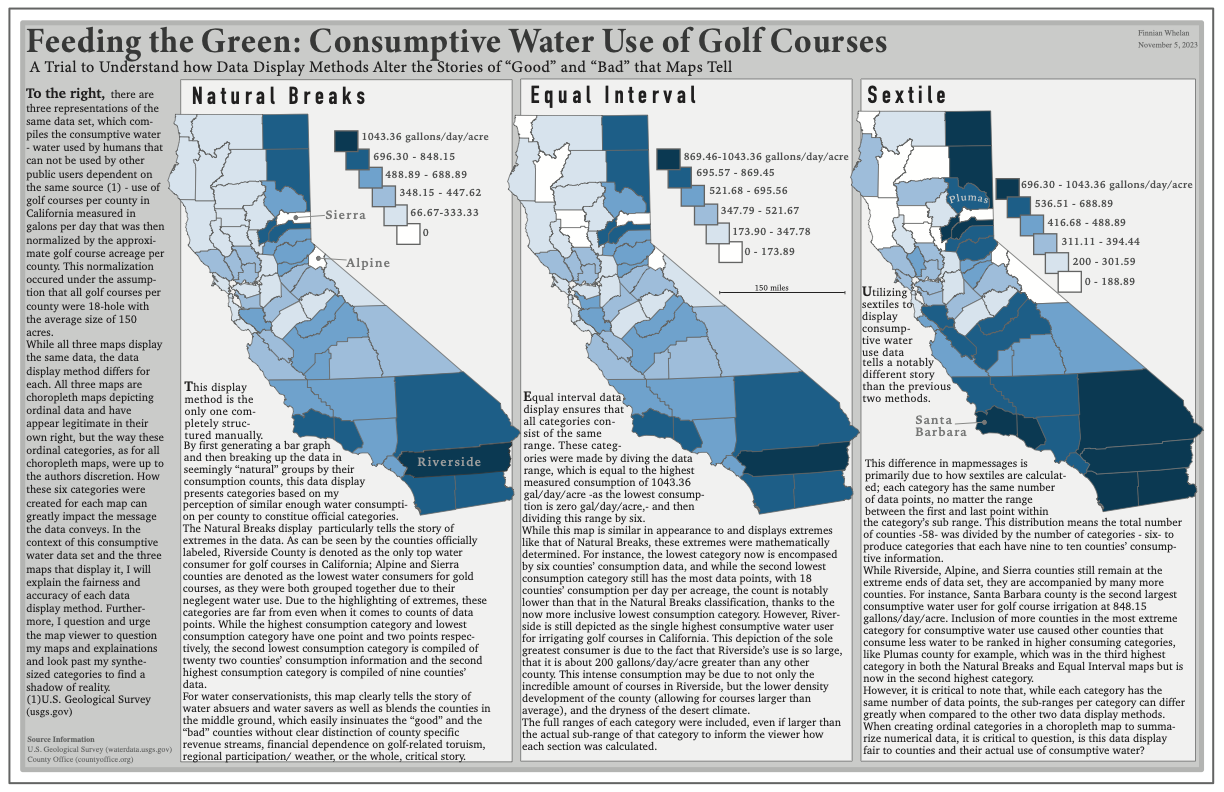
How Data Display Methods Alter a Map’s Message (November 2023) - Consumptive Water Use
Evaluating School and Park Distribution Across Contra Costa’s Zoning (October 2023)

To complete a lab focussed on story telling with publicly available, geo-referenced data, I decided to analyze the distribution of large parks and elementary schools over various zoning types in Contra Costa. All maps, keys, and charts were produced using ArcGIS Pro.

Group Project: Suitability Analysis for New Community Garden (December 2023)
For an upper division GIS course final project, a group of two others and I decided to create a series of suitability maps to locate the best place for a new community garden in Oakland, CA based on environmental justice, census, infrastructural, and topographical data. We utilized geo-analysis skills including digitization, network analysis, and surface calculations. For this project, I specifically digitized historical HOLC redlining maps, created ranking systems for categorical census data, and used geospatial functions to generate suitability rankings in Arc GIS Pro as well as designed our final poster on Adobe Illustrator.
A Tale of Island Ecologies: Historical Ecology Mapping (December 2023)


One of my favorite projects I have ever worked on was this final project for my Cartography class, fall of my senior year at UC Berkeley. This project required looking for very niche data regarding populations of island foxes, golden eagles, and bald eagles as well as nest sites for bald eagles. In some cases, this data was not publicly available, but nonprofit research organizations like Friends of the Island Fox were extremely helpful and offered population count data after I reached out! I not only got to explore one of my favorite subjects through this project - Channel Island Ecology and History,- but also communicated with some wonderful people and got a taste of wildlife data digitization based on historical records and past, peer-reviewed ecological studies. I completed this layout using Adobe Illustrator.